Tuesday, November 4, 2014

Prologue - Lima and Cusco


We visited Lima and Cusco before the 10 Day Trek.

Lima, located on the Pacific Ocean and with  a population of nearly 10 million, is the capital city of Peru.

We had one full day in Lima and visited the Miraflores District and the Plaza de Armas (Main Square).

Cusco, a world heritage city, was the capital of the Inca Empire, and our home for 3 1/2 days.

Located at an elevation of 11,200', Cusco sits in a bowl surrounded by the Andes Mountains.  Much of the city's buildings have red tile roofs so it reminded me of Santa Barbara.

Cusco is a wonderful walking city. We wandered the streets and neighborhoods for several days, so we got a pretty good feel for the city.

The San Blas Barrio, located above the main square and off the main tourist track, was particularly interesting.  You got heady views of the red-tiled city and surrounding mountains from its heights.

The confluence of Inca and Spanish architecture, the cultural mix, the almost daily celebrations or demonstrations, and the impressive culinary scene made Cusco an exciting city to visit.

A major Inca Ruin, Saksaywaman, sits high above the city with commanding views, a logical place to build a fortress.

Although the Spanish did their best (or worst) to destroy and eliminate much of the Inca heritage and replace it with colonial architecture, enough evidence remains making the city a really unique place in the world.

To view the Lima and Cusco albums, click on "Lima and Cusco" below photo:

From Prologue - Lima and Cusco

Ten Day Lodge to Lodge Trek to Machu Picchu


The main reason for my trip to Peru was the REI 10 Day Lodge to Lodge Trek to Machu Picchu on the Salkanty Trail.

Visiting Machu Picchu has been high on my "to do" list and hiking to it through the Andes Mountains sounded even better.  Given my progressive age, tent camping had no appeal and staying in mountain lodges was a very intriguing alternative.

Perusing the REI trek website, I was blown away by the photos of the lodges and mountain scenery.

Sign me up I say!

There are several trails leading to Machu Picchu and the Salkanty Trail is the only one developed with lodges.

Sleeping indoors on comfy beds, nice meals, and hot showers (3 of the 4 lodges even had hot tubs) sounded better than sleeping on the ground.

I was able to convince five other friends to join me on this trek - Dave and Kristina Vandershaf, Bill Staack, Kathy Douglas and Barbara Greenwood.  The Sactown Six as I called ourselves joined six other people on the 10 day trek.

The bottom line:  The REI trek was outstanding and will recommend it to others without hesitation.

The guides - Fernando and Johann - were friendly and experienced, the support was great (horses hauled our gear and cooks followed us for a part of the trek), the accommodations were outstanding, and scenery spectacular.

The total distance of the trek was 42 miles spread over 6 hiking day.  We were in high elevation most of the time with the high point of 15,213' at Salkanty Pass.  The guides did a good job getting us acclimated.

The trek is rated 4 out of 5 in terms of difficulty and I would say that is about right.

To view the trek album, click on "10-Day Lodge to Lodge Trek" below photo:

From 10-Day Lodge to Lodge Trek

Machu Picchu


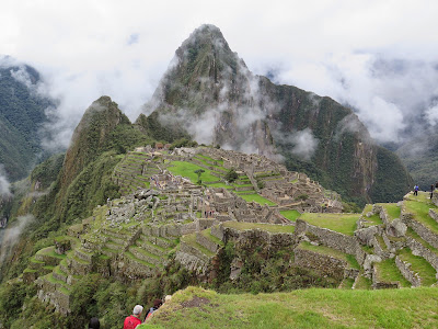
After 6 days trekking over the Andes we arrived in Aqua Caliente, a small city at the foot of Machu Picchu where visitors usually stay before visiting the fabled sacred city in the sky.  Aqua Caliente is a land-locked city tucked in a narrow canyon accessible only by rail.

The itinerary of the REI Tour is to spend a day and a half at MP before catching a train to Cusco.

Being a fit group, we covered almost all of high-points of MP in the first full day - the Inka Bridge, the Sun Gate, and a thorough walk about of the main city complex.

Although I have seen numerous documentaries of MP, seeing one of the seven wonders of the world in person is an out-of-body experience.  It's hard to imagine how an ancient civilization could have constructed such an amazing city on top of a mountain without the aid of modern equipment and tools.

I kept kidding our tour guide, Fernando, that it was impossible for the Incas to accomplish such feats without the aid of extraterrestrial help.  It's totally mind-boggling to see the exacting precision of the stone work of the temples, buildings and walls on such steep terrain.

The logistics alone of supporting such a massive work force is amazing.  What makes it all the more remarkable is the Inca kings employed cooperation among the populace rather than slave labor to build its empire.

To view the album, click on "Machu Picchu" below the photo:

From Machu Picchu

Epilogue - Lake Titicaca Extension


After the 10 day lodge to lodge trek to Machu Picchu, Bill, Kathy, Barbara and I continued to Lake Titicaca on a four day extension.  The extension was also booked through REI.

From Cusco, we took a 10 hour train trip on the Andean Explorer to Puno on the shores of Lake Titicaca.  The train trip was long but was quite luxurious and comfortable and very interesting.

From Cusco's elevation of  11,152', the train climbed to a summit at 14,200' where we took a short break, then continued over the vast altiplano to Lake Titicaca at 12,500'.

The scenery of the altiplano is stark and dramatic and unlike anything I have ever seen before.

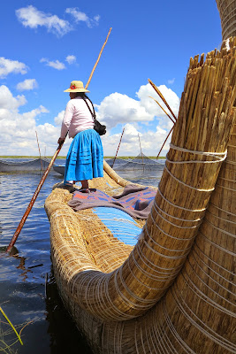
After one night in Puno, we then took a 45 mile boat trip across Lake Titicaca stopping at Uros Isle to visit a floating reed village, a stop at Taquile Island to visit the weavers, and a final stop at Andina Lodge on Suasi Island where we stayed for two nights.

Our time on Suasi Island was very relaxing and gave us a couple days of recovery after the grueling trek over the Andes Mountains.

It was an ideal way to end our Peruvian adventure.

To view the Lake Titicaca album, click on "Lake Titicaca Extension" below the photo:


From Epilogue - Lake Titicaca Extension

Saturday, September 20, 2014

Matt Davis/Willow Camp Trail Hike - Marin County


The Sacramento County Hikers tackled a terrific but brutal 6.5 mile hike in Marin County.  Rich Blackmarr, our hike leader, selected a big loop ascending the Matt Davis Trail beginning in the fabled bohemian town of Stinson Beach and descending Mt. Tam on the Willow Camp Trail.

The hike is rated very strenuous with approximately 1,800' of elevation gain and loss.  The ascent switchbacks up Mt. Tam and the descent drops precipitously with sections of the trail consisting of little ball-bearing pebbles creating treacherous footing.

Coastal fog obscured great ocean views on the ascent but broke up on the descent.  In spite of the challenging hike, everyone had terrific time and celebrated our accomplishment at a local ice cream shop in Stinson Beach.

To view the hike album, click on "Matt Davis/Willow Camp Trail Hike" below photo:

From Matt Davis/Willow Camp Trail Hike

Friday, September 12, 2014

Big Pine Canyon Hike and Glacier Lodge


The annual Eastern Sierra hiking trip by the Sacramento County Hikers was based at the Glacier Lodge and Resort outside the town of Big Pine.  It was a great location for hikes in the high Sierra and White Mountain ranges.

It was close to the Alabama Hills, Manzanar, and Lone Pine which the group also visited on this trip.

Sixteen hikers led by Rich Blackmarr participated in this year's outing.  Most of the hikers stayed in the rustic cabins at the Resort and a few camped in the Lodge's campground.

This blog entry relates to the main hike up the north fork of Big Pine Creek Canyon and views of the Resort and campground.

To view the album, click on "Big Pine Creek Canyon Hike and Glacier Lodge" below photo:

From Big Pine Creek Canyon Hike and Glacier Lodge

Alabama Hills/Lone Pine/Manzanar


On the night before we visited the Alabama Hills near Mt. Whitney, it rained through the night and early morning.  In spite of the dreary weather, Peter Saucerman and I got up at 4 a.m. for the drive to Lone Pine and the Alabama Hills for a photography outing.

The Alabama Hills is a strange and unique environment known for its colorful rocks.  Located between Lone Pine and the abrupt Eastern Sierra escarpment is a sea of golden boulders jutting up from the high desert.

The contrast between the rounded contours and the sharp angular profile of the Eastern Sierra wall is utterly riveting.

Hidden among the contorted clusters of rocks and spires are about a dozen gracefully curved arches.  Windows created by the arches provide striking frames for photos of the Mt. Whitney group and other major peaks.

After a morning tromping around the Alabama Hills, we drove into Lone Pine to visit the Film Museum containing artifacts from movies filmed in the Alabama Hills, and the Manzanar National Historic Site.

To view the album, click on "Alabama Hills/Lone Pine/Manzanar" below photo:

From Alabama Hills/Lone Pine/Manzanar