


 A bike tour to the central coast through the central valley?!
What? . . . you say! How interesting can that be?
Having taken the popular coastal route (Hwy 1) numerous times it was time to find another way. I cobbled together a potential route from several sources - the excellent Krebs cycling maps, AAA maps and roads I'm familiar with from previous rides.
I plotted a route from Sacramento to San Luis Obispo, connecting the dots of some interesting places. The over-night stops were Rio Vista, Tracy, Santa Nella, Mercy Hot Springs, Pinnacles, King City, Ft. Hunter-Liggett, and Paso Robles.
Camping and motelling was split 50/50.
The total distance is 457 miles, ascending 12,362' with average daily miles between 40-60 miles. Some days were a little longer and some shorter. Very doable distances when riding fully loaded.
I floated the idea of this tour with some of my cycle touring buddies and to my surprise, the response was incredibly enthusiastic. Initially, 14 cycling compatriots indicated an interest to participate in the 10 day tour.
In the end, 10 participated in the tour, doing all or parts of the tour. The core group who completed all 10 days were Jay Okada and Keith Wynns from Los Osos, Bob Anderson from Santa Rosa, Herb Lee and myself from Sacramento.
Dennis Engblom joined us for one day, Steve Gibson for 2 1/2 days, Jim Regan and Peter Saucerman for 7 days, and Harvey Cohen from San Luis Obispo for 5 days.
Weather-wise, we couldn't have timed the tour any better. The longest and wettest winter in decades ended two days before the tour started and we enjoyed 11 dry days. North winds arose on the two days we were headed down the Central Valley so we benefited from 20-30 mph tailwinds.
Coffee houses, pie shops, and small markets popped up in the middle of nowhere when our energy level were beginning to sag. The tour was blessed given that we were riding on mostly unexplored roads.
The route and terrain turned out to be varied, interesting and we were treated to some unique experiences. This was cycle touring at its best and this is why we do it.
This blog consists of three parts. Continue to scroll down or click on "old posts" to continue the tour.
For enlarged view, click on pic once/twice
 On the Riverfront Promenade
Day 1 Leaving Sac for Rio Vista, a 52 mile ride - Me, Herb, Jay, Keith, Dennis, Bob
 Jay in front of the Tower Bridge
 Cruising along Babel Slough (above and below)
 Delta vineyard
 First stop - lunch at Shorty's near Clarksburg
 See ya' Mike!
Mike had family obligations and couldn't make the tour. He rode with us to Shorty's and returned home. We'll miss ya' Mike.
 Crossing the Courtland Bridge
 Stopping off to visit Historic Locke, a river town established by early Chinese immigrants
 Checking out Main Street
 A new monument honoring the town's Chinese heritage
 Keith and Steve checking out Al's, a popular eatery
 No burn-outs from loaded bikes
 Next stop Walnut Grove
 Catching the first of two ferrys . . . crossing Steamboat Slough
 The only big climb of the day - up a river levee
 More speed Steve! . . . you're teetering
 Taking the Real McCoy II, a new ferry crossing to Rio Vista
 Dennis breaking camp at Sandy Beach Campground in Rio Vista where we spent the first night
 Sunrise over Sac River
 Yellow lupine in peak bloom
 Early morning on a lanquid river
 We crossed the infamous Hwy 12 Bridge from Rio Vista to Hwy 160 - no shoulder and heavy truck traffic. We puckered up and raced across the bridge.
 See ya' Dennis!
Dennis could only make one day of the tour. He left for home after camping with us.
 Wind turbines in the Montezuma Hills
 Day 2 Rio Vista to Tracy, a 54 mile day
Circumnavigating the Levee Road on Sherman Island . . . and heading to Antioch
 Fishing the San Joaquin River
 The very wet winter is causing a population explosion of rodents which means it will be a banner year for reptiles. I saw numerous snakes sunning themselves on the roads.
 Our big climb of the day over the Antioch Bridge
 About a 4' wide bike lane but still kinda' scary with all the traffic
 A great view of Mt. Diablo and Antioch from the top of the bridge
 Pick it up Steve!
A big truck bearing down on Steve
 Stopping off at the Black Bear Diner in Oakley for a hearty lunch
 A humongous taco salad . . . Steve has become a Black Bear convert
 Tackling the rolling hills on Bruns Road between Byron and Tracy
 Slaking our thirst at Mountain House on Grantline Road near Tracy
 We woke up to northwinds blowing 20-30 mph. The palm trees were tilting south.
Day 3 Tracy to Santa Nella, a 60 mile ride down the Central Valley
 Serendipity rules! We encounter the All American Expresso out in the middle of nowhere
 Great coffee and nice display of fresh fruit
 The barista makes a mean latte
 The restroom is behind the cup-o-joe
 Cheers!
The lads taking a nice break
 Yeehaa! With tailwinds at 20-30 mph, we were blowing down Kasson Road making short a 60 mile day.
 Watching a nifty planting machine
 See ya' Steve!
Steve rode with us for 2 1/2 days and departed in Patterson
 Swingin' through Historic Downtown Newman
 Riding past a wildlife refuge outside Los Banos
Day 4 Santa Nella to Mercy Hot Springs, a 62 mile day

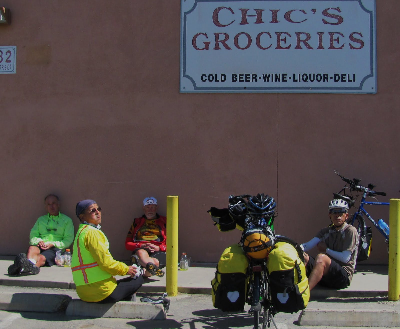 A strategic stop at Chic's Market in Dos Palos, a tiny burg in the Big Valley
 Fred Sanford and Son drove up in this vintage trailer
Dos Palos is a hard-scrabble valley town with not much going on
 Leaving the flat central valley and turning west toward the hills on Shields Av.
 This nervous yappy pooch guarded the home where we took a short break
 Crossing the CA Acquaduct
 The first big climb on Little Panoche Road on our way to Mercy Hot Springs
 The barren Panoche Hills
 Finding some shade and setting up camp at Mercy Hot Springs
 Hey Peter . . . You the MAN!
Peter and Jim joined the tour at Mercy. They brought us sub-sandwiches from Quiznos and dessert from Freeport Bakery.
 The Taco Bell motif of the Hot Spring's office
 Mercy Hot Springs is a literal oasis in the desert
 Recently built hot tubs were a godsend
 Peter and Keith lounging by the pool
 You can rent rustic cabins if you want to go high brow
 A fledgling owl
Mercy is a great place for birders. A family of short-eared owls roost in the trees.

 The Killing Field!
Mice heads are too big for the owls to digest so they drop them on the ground
 Little Panoche Hills at sunset are sublime
 The gang of 7 leaving Mercy HS
Day 5 Mercy Hot Springs to Pinnacle, a 54 mile day
 Small Wheel Society - Peter with his Moulten and Herb with Bike Friday
 Leaving the Hot Springs on Little Panoche Road and into the hills
 A long steady climb to the first summit

 Up and over the summit and into Panoche Valley
 Panoche Valley - stark yet very beautiful
 The juxtaposition of brown valley, rolling hills and green mountains is mesmerizing

 Good sense of humor at the Panoche Inn
 The road swings north and climbs toward Hwy 25 and Paicines
 A gradual climb to the summit

 Taking a break at the high point
 Beginning of a long gradual descent to Paicines
 A fab rest-stop at the Paicines store - tasty home-made burritos and tamales
 Attack dog pestering for a bite
 Turning on Hwy 25 toward the Pinnacles takes you through bucolic country-side
 Jim cresting the summit
Another butt-busting climb before reaching the Pinnacles
 BA is in good form and riding tough on this tour
No comments:
Post a Comment